
“Annotation Support” has won a notable place among global data annotation providers by always delivering high-quality, flexible, and adjustable solutions. Let’s look at the reasons it separates itself from the other top companies in the industry.
1. Industry-Specific Expertise
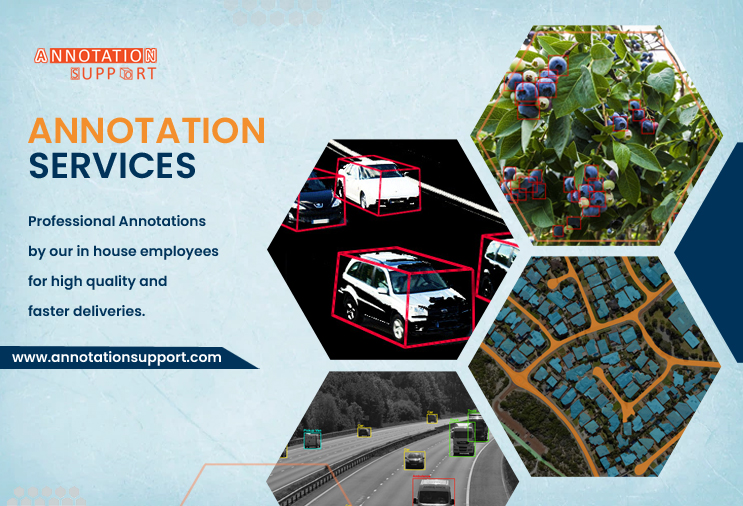
“Annotation Support” covers in-depth information in many different industries.
- For example, radiology image labelling is an aspect of healthcare.
- Autonomous vehicles include LiDAR technology and 3D point cloud annotations.
- Areas of agricultural tech include things like mapping different crop types and checking yields.
- Retail and E-commerce tasks such as tagging products and doing sentiment analysis
- Geospatial AI covers tasks such as annotating satellite images for example.
As a result, clients can expect data that addresses their industries in particular.
2. Wide Range of Annotation Services
From the basic step of rendering as 2D boxes to following the movement of 3D objects, “Annotation Support” handles many types of object detection.
- Some of the important types of data are Image, Video, Text, Audio, and Sensor Data Annotation
- In the case of maps, Polygon, Polyline, Key point, Semantic Segmentation are important data types.
- The NER, sentiment tagging, and transcription methods could be applied.
- Medical and pharmaceutical labelling for health professionals
The wide range of services attracts clients from all kinds of AI training industries.
3. Quality-Driven Process
“Annotation Support” has these features:
- Many levels of review and approval are set in place.
- People who have expertise in the subject
- Processes that have gained ISO certification and follow the GDPR
For models to succeed, accuracy and consistency need to be found in its services.
4. Scalable Workforce and Tools
No matter if it is a small startup or a big enterprise, “Annotation Support” can match the needs of any organization.
- Creating extra team members when urgent deadlines are approaching
- The use of special built-in software or integration with the client’s software
- APIs are used to ensure the automation of different workflows.
As a result, different projects will benefit from flexibility and lower costs.
5. Secure and Confidential Operations
Ensuring security is very important in such projects. “Annotation Support” brings the following benefits:
- Data encryption is used from start to finish in the process.
- Using systems that handle access and are secure
- Agents are obliged by NDA and must comply with HIPAA, SOC 2, and other important standards
For this reason, our services matter most to companies in healthcare, fintech, and legal tech.
6. Global Clientele and Proven Track Record
“Annotation Support” has:
- Served clients in North America, Europe, Asia, and the Middle East
- Partnered with AI-first startups to Fortune 500 companies
- Delivered millions of annotated data units with high satisfaction rates
Global reach and a strong track record reinforce its credibility.
7. Innovation and Customization
- Building your annotation tools and dashboards inside the organization
- Learning new trends such as self-supervised learning and active learning
- Workflow design that matches the important goals of each client
It allows data to be labelled with a goal of improving AI in the future.
That’s why “Annotation Support” is notable; it gathers domain expertise, looks after technological aspects, tests rigorously for quality, addresses security matters, and delivers results internationally. Because of these strengths, companies prefer to use it when developing dependable, error-free, and expandable AI systems.